

S454 Gamsöfen round


- culturally interesting
- Flatly
Interactive elevation profile
Create PDF
Tour-Details
Paths covering:
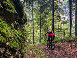
The Gamsöfen loop S454, 36.4 km, 990 m elevation gain leads via the Hoisnradalm with distant views of Lake Wolfgangsee and on through impressive natural landscapes with technical delicacies.
Technique: *****
Quality of experience: *****
Recommended season:
- April
- May
- June
- July
- August
- September
- October
Properties:
- Loop
- Scenic
- Refreshment stops available
- Cultural/historical value
- Geological highlights
The Gamsöfen Tour S454 has a crisp uphill below the Hoisnrad crossing as well as trail sections in the area of the Gamsöfen, which are also rideable with sufficient riding technique.
In addition to the sporting challenge, the following highlights make this tour an unforgettable experience:
- A leisurely ride along the Römerweg towards the Wildenstein castle ruins (km 3.8).
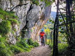
- At the Anzenberg at km 11.1, a detour to the Ewige Wand, the journey continues on forest roads
- past old salt tunnels via a crisp uphill to the Hoisnradalm (km 22.9) for a refreshment stop with a distant view of Lake Wolfgangsee
- After sufficient refreshments, the route continues through the beautiful natural area of the Leckenmoos to the Gamsöfen
- with a short and bumpy trail sequence (km 28.8), some of you will take a short push section here (600 m 76 tm) to then pedal above the Rettenbach stream to Bad Ischl.
Directions:
We start in the middle of Bad Ischl at the Trinkhalle in the direction of Traun and turn right onto the Salzkammergut cycle path R2 in the direction of Hallstatt, which we follow upstream. In the Esplanade area, we pay attention to the short push sign at Zauner and after around 1.1 km turn right up Engleitenstraße. After around 200 m, we turn left up into Lindaustraße and then immediately left into Mastaliergasse (km 1.3).
We cross the Mastaliergasse junction and after 200 m turn left into Rabenneststraße (km 1.5), which we follow for around 1.1 km before crossing the Kaltenbach (km 2.7 ) straight ahead in a left-hand bend (km 2.6) and are now on Römerstraße.
After around 300 m, we pass the barrier (km 3.0) to the forest road and follow this in the direction of Wildenstein castle ruins (km 3.8), which is around 800 m further along the path on the left. After around 1.9km, slightly downhill on the Römerweg, we leave the forest road to the right and join the Salzkammergutradweg R2 (km 5.7).
We follow the Salzkammergut cycle path in the direction of Bad Goisern, cross the Traun river and cross Lauffen before finally turning right after 2 km, crossing under the main road and leaving the Salzkammergut cycle path (km 7.7) onto Anzenmühlenstraße.
Passing the Anzenaumühle open-air museum, the path changes from asphalt to gravel (km 8.0) after around 300 m to the top left. For the next 2.4 km there is a chance of getting a little dusty from the truck traffic from the Anzenaukogl quarry.
After another 700 m in a left-hand bend, we can make a detour (km 11.1) to the Ewige Wand, which is located directly on the forest road to our right. We continue straight ahead for around 1.8 km. After a slight downhill section at the Gstichstraße / Anzenbergstraße junction in the forest, we turn left downhill in a right-hand bend (km 12.9) and after around 2.5 km turn sharp right uphill into Brunnleitenstraße (km 15.4).
We follow the Brunnleitenstraße past the Steinbergstollen in a left-hand bend and after around 2.2 km uphill at the next junction (km 17.6), we keep slightly left, cross the Radgrabenbach stream and after around 2.4 km on an almost flat stretch in a right-hand bend at km 20.0 we put our uphill skills to the test.
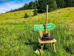
Now just take a deep breath and find your line to pedal steeply up this bumpy trail (400m 60m). If you can't manage it, use the push aid and look forward to the opportunity to stop for refreshments at the Hoisnradalm (km 21.6 ), which appears shortly after 2.2 km.
After a well-earned rest, we return to the Hoisnradalm junction (km 22.9) and turn sharp left past Leckenmoos in the direction of Tauern. Follow the forest road slightly uphill for 1.5 km until the next turn-off (km 24.4) to the left below.
The route goes downhill through the beautiful natural landscape below the Tauern. After around 3.5 km and a short uphill section, we turn left at an acute angle (km 27.9).
After around 1 km, there is a hunting lodge on the left of the path in a left-hand bend. Around 800 m after the h ut is the easily overlooked entrance (km 29.7) to the trail to the Gamsöfen.
The turn-off leads from the forest road down to the right on an old train path, which is damp, bumpy and adventurous for around 600 m until we reach the path above the Rettenbachschlucht gorge.
We turn left down here (km 30.3), caution is advised as we are ultimately in a gorge. The path leads us through the gorge downhill in the forest until, after around 2.2 km, we emerge from the forest (km 32.5) and continue straight ahead onto the field path. We stay on the field path for around 300 m and leave it in the left-hand bend (km 32.8) to continue straight ahead for another 200 m, following the meadow path to the right into Rosenkranzgasse (km 33.0) on asphalt.
200 m later at the crossroads (km 33.2), we turn sharp right, cross the Rettenbach and immediately afterwards turn into Hubhanslauweg in the direction of Bad Ischl. We follow the path through the settlement along the Rettenbach downstream until after about 400 m we turn right into Steinfeldstraße and cross the Rettenbach again after about 800 m (km 34.7).
We go downhill on asphalt along the railroad, cross the B145 and a little later the Traun to turn left onto the cycle path R2 (km 35.5) following the Traun upstream.
We follow the cycle path R2 900 m in the direction of Bad Goisern and reach our tour start at the Trinkhalle in Bad Ischl.
Tip:
Stop off at the Hoisnradalm at km 22.9 for a homemade raspberry and thyme juice, followed by an adventurous descent through the Gamsöfen.
Safety guidelines:
The Gamsöfen tour is a circular tour and is signposted with the number S454. Tours with 400 numbers have a route length of up to 50 km. The specified riding times are pure net riding times with the E-MTB without breaks such as photo stops, refreshment stops, etc..
Special care is required in Bad Ischl during the pushing passage on the Esplanade in the hustle and bustle of the guests, on the ascent on the Anzenberg to the trucks from the quarry.
To make the day perfect, here are a few tips that are worth bearing in mind before every tour.
In addition, be aware that you are in the mountains and that personal responsibility plays a major role. This applies to your choice of route, the expected weather and the odd dead zone where you won 't find a mobile phone connection.
Equipment:
Please note that any (e)MTB tour must always be undertaken with perfect equipment. Below you will find a few tips on preparation and equipment.
Additional information:
In Bad Ischl, all mountain bike tours start at the Trinkhalle on Auböckplatz. The tours are signposted and numbered. All tours are also accessible from Bad Ischl train station.
We look forward to comments, tips, constructive criticism and of course thousands of photos of your tour with the hashtag #badischl in your social media posts.
As new figures on the playing field of mountain and leisure sports enthusiasts, we e-MTB riders have a particular duty to behave appropriately.
In Graubünden, bikers and hikers share the trails. A project that should set a precedent. But this is only possible with mutual respect. Black sheep set us back years.
With common rules we can ensure that the forest continues to offer a unique recreational and living space as well as a workplace for everyone.
Information on cycling in the forest from the Federal Ministry of Agriculture, Regions and Tourism.
further information:
- Flatly
- Board possible
Getting there
Coming from Wolfgangsee or Bad Goisern we recommend the parking lot Dumbastraße, coming from Traunsee the parking lot Salinenplatz. Coming from Bad Goisern, the parking lot in Lauffen would also be a tip as the tour leads right past here.
Public Transit
By train (OBB) to Bad Ischl.
Parking
Parking lot Bad Ischl Dumbastraße, PJ35+XW Bad Ischl, Kaltenbachstraße 25, 4820 Bad Ischl (subject to charge)
Parking lot Bad Ischl Salinenplatz, PJ6F+6R Bad Ischl, Salinenpl. 1, 4820 Bad Ischl (subject to charge)
Lauffen parking lot, 47.673329, 13.616531, Lauffner Marktstraße (few spaces)
- Spring
- Summer
- Autumn
Please get in touch for more information.
Auböckplatz 5 - Trinkhalle
4820 Bad Ischl
Phone +43 6132 27757 - 0
E-Mail office@badischl.at
Web badischl.salzkammergut.at/
Vis-à-vis users
1. The tours presented for hiking, walking, biking and road biking, mountain biking, motorbiking, horseback riding, climbing, cross-country skiing, and going on skiing and snowshoe tours etc. are to be considered non-paid tour recommendations and only serve as non-binding information. We have no intention of concluding a contract with the users of this website. The utilisation of the data does not lead to the establishment of a contract with us.
The data may only be used for private use; any commercial use is prohibited. In particular, it is not permissible to offer the data on commercially run websites, file-sharing platforms etc. or to use it to develop commercial products. Downloading data does not imply that users are granted rights to the data concerned.
The tour recommendations posted were created with utmost care; nevertheless, we assume no liability for the correctness and completeness of the information.
We point out that neither the tour recommendations included on this website nor the associated data and information were posted by us, but rather by third parties (Art. 16 Austrian E-Commerce Act). We have no influence on whether the details provided (e.g. distance, level of difficulty, change in altitude, description etc.) are authentic, correct and complete. We do not review these third-party contents. For this reason, we assume no liability for the authenticity, correctness and completeness of the information.
Construction-related measures or other influences (e.g. landslides and similar occurrences) can lead to temporary or permanent changes in a route (e.g. loss of a bridge and similar occurrences). Such occurrences can lead to part of the route or the entire route becoming impassable.
The use of the data as well as undertaking (riding, walking, taking etc.) the recommended tours or using the network of paths occurs at users’ own risk and on their authority. In particular, users themselves are responsible for the choice of route, outdoor orientation, adherence to traffic rules, supplies and equipment for tours listed in Point 1 (e.g. bicycle etc.), wearing a helmet, estimating their own fitness, recognising dangers and maintaining an appropriate velocity. We exclude ourselves from any liability whatsoever for damages, in particular accidents, that occur whilst taking part in the recommended tours.
2.Some of the tours lead over roads with normal traffic conditions. Please observe that there is an increased risk which can be avoided by means of appropriate attention and proper estimation and implementation of one’s own abilities. For this reason, please travel a route that is unfamiliar to you slowly and with special care. Pay constant attention to potential dangers and always observe traffic. Do not leave the routes featured in descriptions.
The potential use of private roads, in particular forestry roads and agricultural transport roads, can be subject to legal restrictions, which must be observed and adhered to.
The normal traffic rules apply. Each user (e.g. biker, motorbiker) is responsible for adhering to these rules and maintaining his/her bike/vehicle and its equipment (lights, brakes etc.) in good working order. Each user is also responsible for ensuring that he/she rides at a velocity that is appropriate for the conditions and his/her skill level and for maintaining sufficient distance to the rider in front. We explicitly recommend adjusting velocity to correspond to the respective field of vision, wearing a helmet, using reflective clothing (or similar) and employing bicycle lights in line with regulations.
3.Each tour requires good physical fitness as well as detailed planning. We explicitly recommend only taking the tours in the case of optimal healthiness.
We recommend that you conclude an accident and liability insurance policy. Use an onboard computer that displays the respective kilometres travelled per day and is calibrated for the front wheel.
4.Special for mountain bikers – Fair-play rules:
Mountain biking is one of the most wonderful outdoor leisure-time activities. Whilst biking or on a mountain biking tour, mountains and lakes, meadows and cabins are re-discovered in new ways. A couple of rules for fair play in the forest help to avoid conflicts whilst mountain biking.
a.Pedestrians have the right of way: We are accommodating and friendly to pedestrians and hikers. Upon encountering these fellow travellers, we alert them by using the bicycle bell and slowly overtake them. We avoid paths with heavy pedestrian traffic altogether. Take nature into account: We do not leave refuse behind.
b.The braking distance should be half of the total distance visible: We ride at a controlled pace, are ready to brake and maintain a braking distance half as long as the total distance visible, especially in curves, because we always have to count on obstacles on the path. Damage to the path, stones, branches, wood piles, grazing livestock, cattle grids, barriers, tractor-type forestry machines and authorised vehicles pose dangers that we need to be ready for.
c.Don’t drink and drive!: Do not drink alcohol when mountain biking. Take care at stop-off points (dealing with bike racks, dirty shoes or clothing).
It is obligatory to provide first aid!
d.Marked routes, closed paths and blockades: Keep to the marked routes, observe the blockades and accept that these roads are primarily for agricultural and forestry use!
Blockades can often not be avoided and are in your own interest. Biking beyond the intended path and outside of opening times is punishable and turns us into illegal bikers.
e.We are guests in the forest and behave accordingly, including vis-à-vis forestry and hunting staff. Whilst mountain biking, mobile telephones and music players are forbidden! Biking requires your full attention.
f.Avoid unnecessary noise. Out of consideration to the animals living in the wild, we only bike during full daylight. As a principle, we always wear our helmet (even when riding uphill)! Don’t forget emergency supplies: We always have a repair set and bandages along.
g.Don’t overestimate your skills: We should not overdo it when it comes to biking technique and physical fitness. Take the level of difficulty posed by the route into consideration and make a precise estimate of your experience and skills as a biker (braking, bell, lights)!
h.Close gates: We approach grazing livestock at a walking pace and close every gate behind us. We should avoid causing escape and panic reactions in the animals. Nothing stands in the way of the fun and athletic challenge in the mountains and forests!
i.Traffic rules: The general traffic rules (StVO) apply for all the mountain biking routes and we adhere to them. Our bike therefore needs to be in perfect technical condition and equipped in line with the traffic rules, including brakes, a bell and lights. We inspect and service our mountain bikes regularly anyway.
5.We assume no liability for the contents of external websites; in particular, we assume no liability for their statements and contents. Moreover, we have no influence on the design or contents of the websites to which hyperlinks on www.badischl.at lead or from which hyperlinks lead to www.badischl.at. There is no on-going review of websites to which hyperlinks on www.badischl.at lead or from which hyperlinks lead to www.badischl.at. We do not appropriate the contents of websites to which hyperlinks on www.badischl.at lead or from which hyperlinks lead to www.badischl.at.
Vis-à-vis bloggers
PLEASE OBSERVE:
1. Each of your tour recommendations for hiking, walking, biking and road biking, mountain biking, motorbiking, horseback riding, climbing, cross-country skiing, and going on skiing and snowshoe tours etc., along with other details and information, is free of charge. In particular regarding the correctness of the information, we assume no liability, nor do we assume any liability whatsoever for the consequences of the use of your tour recommendation by a third party (in particular by a user of this website). We do not review the tour recommendations you post, including other details and information, at any time.
We have no intention of concluding a contract with persons who post tour recommendations and/or other details and information on this website. Posting data (information) does not imply that a contract has been concluded.
By recommending a tour, we assume special responsibility vis-à-vis other athletes. Please take this responsibility seriously and describe your tour recommendation with utmost care and to the best of your knowledge and belief.
2.Your tour recommendations must therefore clearly and unambiguously include at least the following criteria and provide a sufficiently detailed description:
• Starting point
• Detailed route description
• Distance/Overall distance
• Level of difficulty
• Dangerous spots
• Average duration of trip
• Change in altitude
• Finishing point.
If possible, please provide the change in altitude.
3.When you post a tour recommendation, you give us the order to save your tour recommendation and/or the details you provide on our website and to make it/them accessible to third parties, in particular to users of this website, in the long term. We reserve the right to block or delete tour recommendations and/or other details and/or information that you post, either partially or entirely, at any time without providing a justification. Should this occur, it grants you no rights whatsoever.
Thank you for your efforts!
4. We are not responsible for the contents of external websites; in particular, we do not assume any liability for their statements or contents. Furthermore, we do not influence the design or contents of websites that can be accessed from www.badischl.at via hyperlinks or that use hyperlinks to refer to www.badischl.at. The websites that can be accessed from www.badischl.at via hyperlinks or that use hyperlinks to refer to www.badischl.at are not regularly monitored. Furthermore, we do not assume any claims to the websites that can be accessed from www.badischl.at via hyperlinks or that use hyperlinks to refer to www.badischl.at.
Interactive elevation profile
Create PDF
Tour-Details
Paths covering: